The Tales of the Geek Underclass
College Map

The Tales of the
Greek Underclass
- Introduction and Disclaimer
- General Description of St Francis's
- The Year 8 Camp
- Five Deranged Teachers
- The Year 9 Camp: Part 1
- The Year 9 Camp: Part 2
- The Year 9 Camp: Part 3
- The Pathetic Circle of the Dance Class Damned: Part 1
- The Pathetic Circle of the Dance Class Damned: Part 2
- Map
- The Crest
- Contact
The Further Tales
- The Third Geek Astronomical Expedition: Part 1
- The Third Geek Astronomical Expedition: Part 2
- The Third Geek Astronomical Expedition: Part 3
- The Hideous Adventures of Denys in the Lair of the Glossalalia Gang: Part 1
- The Hideous Adventures of Denys in the Lair of the Glossalalia Gang: Part 2
The Tales of the Geek Underclass are dedicated to the Memory of
Douglas Noel Adams
1952 - 2001
without whom I would have no idea how to write.
College Maps
Red areas are the elevated walkways. These were off limits during lunch and recess lest anyone got 'accidently' thrown over the edge. Stairs consisted of a puke green stairwell in the middle of block N, a rickety iron fire escape at the west end of the same block, the main staircase under the tower (K) and a flight overlooking the Principal's private garden between blocks J and Q. Blue areas are covered, ground level walkways. Two storey buildings were concentrated around the quadrangle and are indicated with a darker shade of grey.
Circa 1989
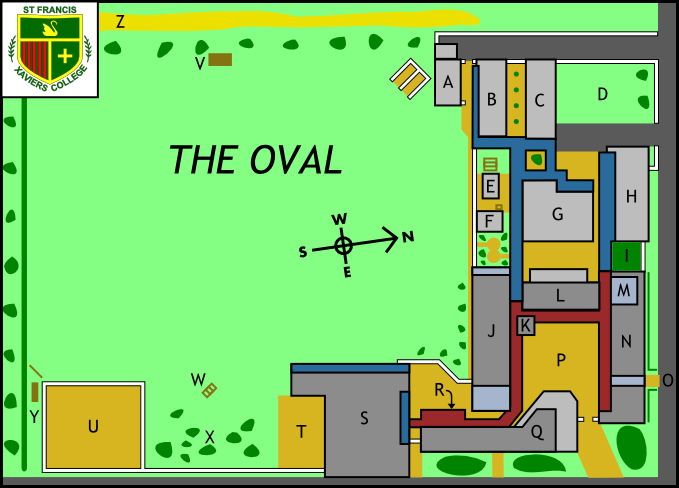
- A: Plastics Workshop (and Frank the Gardner's lean-to).
- B: Manual Arts Block. Metalwork, Woodwork and Technical Drawing.
- C: Social Studies Block. Location of the best toilets in the school.
- D: The Back Oval
- E: Room 18 (Demountable). Removed circa 1993.
- F: Room 17 (Demountable). Removed circa 1993.
- G: Multi Purpose Area (MPA). Also Social Studies rooms, Italian Room and lair of the Chaplain and Counsellors.
- H: Home Economics Block. Food and Nutrition and Fabricwork. Built in 1989 to replace the one torched by arsonists in 1988.
- I: Plant Nursery. Destroyed around 1991-1992 and built over with a new computer lab, typing room, social studies rooms, staircase and lift.
- J: Science Labs (upstairs). English rooms (with folding walls) and dodgy toilets (downstairs).
- K: Main Staircase and Tower with rain gauge. The highest point in the school.
- L: Biology and Computer Labs (upstairs) Library (Downstairs). The library was expanded eastwards in around 1990-1991.
- M: Undercroft. Converted to maths classrooms around 1989-1990.
- N: Maths rooms. The oldest and most run down part of the school.
- O: Side Entrance. A tunnel through the math block with a puke green stairwell to the upper level.
- P: The Quadrangle. No map could adequately depict its non-quadrangleness. Upgraded with a gazebo, flower beds and brick paving in 1989-1990.
- Q: Art rooms (upstairs). Administration and staff room (downstairs). Expanded 1989-1990.
- R: Canteen (downstairs). A new Art room was built on top in 1989-1990.
- S: Leeroy Mulder Memorial Gym including stage and chapel. Music rooms upstairs.
- T: Basketball Court. A fire escape led up to the top level of the gym.
- U: Decaying netball courts. Demolished and replaced with a massive array of basketball/netball courts in 1992-1993.
- V: The Score Board. Home of the Geek Underclass in exile while the Bus Bay was constructed in 1990.
- W: The Monkey-Bars. Home of the Geek Underclass 1989-1990.
- X: The Abode of the Geeks. Converted into the Bus Bay in 1990.
- Y: Strange wooden climbing frame and non-balancing log.
- Z: The Gravelly Track. De-facto western school boundary.
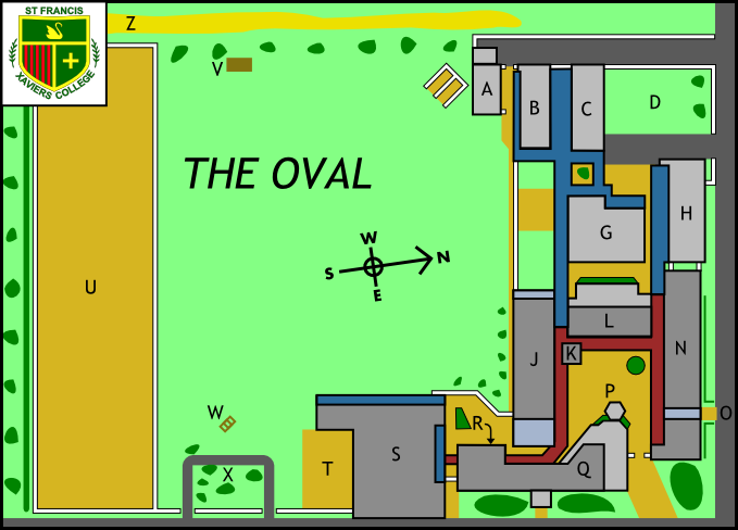
Circa 1993
- « Back
- Home
- Forwards »